
Navigation is a critical yet frequently overlooked component of the visitor experience, often serving as the invisible thread that connects a traveler’s expectations to their physical reality on the ground. Within the lush landscapes of Lafourche Parish, a comprehensive wayfinding signage initiative has emerged as a cornerstone of a broader strategy to modernize local infrastructure and support the regional economy. This project, which involves the installation of 164 new vehicular signs, represents a coordinated effort between Louisiana’s Cajun Bayou Tourism and the local government to address specific logistical gaps. For years, visitors have navigated the winding roads of the bayou with varying degrees of success, but a formal analysis by Randall Travel Marketing recently confirmed that inadequate signage remained a primary source of frustration. By implementing a standardized system, the parish aims to transform these navigational hurdles into a seamless journey that encourages deeper exploration and higher spending.
Developing a Unified Visual Identity for the Region
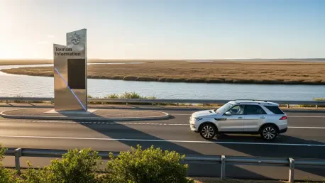
Beyond the simple utility of directing traffic, the signage project serves as a physical extension of a unified brand identity designed to resonate with global and domestic tourists. Every sign is carefully color-coordinated to reflect the aesthetic of the interior exhibits found within the recently opened Visitor Center in Raceland, which serves as the primary gateway for travelers entering the area. This visual consistency ensures that the transition from a digital or indoor planning phase to the actual exploration of the bayou feels intuitive rather than disjointed. By utilizing a specific palette and design language, the parish creates a sense of place that is immediately recognizable, helping to build brand equity in a competitive tourism market. This strategy is not merely about aesthetics; it is about creating a psychological sense of security for the traveler. When a visitor sees a familiar design on a roadside sign, it reinforces the feeling that they are in a curated and welcoming destination.
The scope of this initiative is remarkably broad, extending well beyond basic highway markers to encompass a diverse array of points of interest that define the local culture. Each municipality within Lafourche Parish is included in the new network, with signs directing traffic to essential historical sites, public parks, sports complexes, and fairgrounds that host the region’s famous festivals. Additionally, the system prioritizes access to boat launches and major tourist attractions, ensuring that those seeking outdoor recreation can find their way to the water without difficulty. This comprehensive coverage reflects a strategic consensus among regional leaders that high-quality infrastructure is essential for maintaining the status of the parish as a premier destination. By highlighting these specific locations, the signage effectively functions as a passive marketing tool, alerting passersby to amenities and experiences they might have otherwise overlooked. This visibility is crucial for distributing the economic benefits across the entire geography.
Strategic Implementation and Economic Implications
The successful rollout of this signage network is the result of a collaborative framework established between Parish President Mitch Orgeron and Jay Schexnaydre, the CEO of Louisiana’s Cajun Bayou Tourism. This partnership bridged the gap between public works and specialized marketing, ensuring that the physical markers met both safety standards and branding goals. Leadership emphasized that the goal was to facilitate an “up and down the bayou” movement, encouraging visitors to venture beyond the main thoroughfares and discover the hidden gems located in the smaller communities. By making the geography easier to navigate for first-time visitors, the organization expected to see a measurable increase in the average length of stay. When travelers felt confident in their ability to find their way back or reach their next destination, they were more likely to stop at a local restaurant or visit a roadside shop. This increased exploration directly translated into higher tax revenues and support for the local economy.
As the phased installation progressed through 2026 and moved toward 2028, the focus shifted from simple placement to long-term maintenance and digital integration. Stakeholders recognized that physical signs had to exist in harmony with modern GPS technologies to provide a truly comprehensive navigational experience. Moving forward, local authorities could leverage this physical infrastructure as a foundation for augmented reality tours or interactive maps that synced with the wayfinding system. Maintaining the physical condition of these markers remained a priority to preserve the professional image of the destination against the wear of the humid coastal environment. The project demonstrated that minor investments in infrastructure yielded significant returns in visitor satisfaction and regional visibility. Future planners should continue to monitor visitor feedback to identify any remaining gaps in the network. By treating navigation as a dynamic service, the parish solidified its reputation as a forward-thinking destination.